...
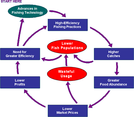
Figure 1. Taken from Grinning Planet.
| Wiki Markup |
|---|
\[LINK TO CHILDSHORT PAGETERM 1IMPROVEMENT\] |
| Wiki Markup |
|---|
\[LINK TO CHILDLONG PAGETERM 2REGULATION\] |
| Wiki Markup |
|---|
\[LINK TO CHILDGPS PAGETRACKING 3UNITS\] |
A combination of new technologies makes selectivity and habitat conservation possible, but conversion to these new methods will be costly and difficult. To ease the transition to more expensive equipment, we propose that subsidies be redirected to support sustainable fishing. Along these economic lines, tax deductions will also encourage environmentally-friendly methods. The technologies themselves include digital imaging for catch specificity, line tension sensors to indicate net content, and electronic ticklers with depth sensors for trawl nets. These and other steps will allow fisherman, even in large-scale commercial corporations, to catch fish of proper size and species without damaging the precious ocean environment. A shift of the magnitude necessary to restore the fisheries will take time and commitment from across the globe. Honed regulations from supportive governments can encourage sustainable technologies to restore declining fisheries and unify the fishing community worldwide.
...
Such a device is also capable of receiving signals via satellite. This will be essential for alerting vessels in danger and allowing fishing boats to know the whereabouts of other fishing boats in the area. We discussed earlier the need for a flexible management strategy that can be easily modified to accommodate changes in the ecosystem, and such management strategies might include a system of time and area closures. A tracking system will allow fishermen to determine their exact position and how close they are to the closed areas that are in effect that day. Additionally, the device can be programmed keep a tally on the amount of fish caught by that particular vessel and how much of the Total Allowable Catch (TAC) has been caught.
There Relevant products are several relevant products already on the market. Chartplotters, currently available for under $500, provide sport fishermen with information about a boat's location through an electronic navigational chart, as well as the vessel's direction and speed. Applied Satellite Technologies, Ltd., based in the United Kingdom, has also developed a line of such products called Thrane & Thrane.
...
The United States is currently seeking a Nation Wide Automatic Identification System (NAIS). Northrop Grumman will compete for the U.S. Coast Guards NAIS proposal. The plan is to develop a tamper proof ID system that will "continually transmit and receive voiceless exchange of vessel data, including vessel identity, position, speed, course, destination and other data of critical interest for navigation safety, marine mobility and maritime security." 4 (Staff Writers, 2007) This system will allow the Coast Guard to protect closed areas, regulate the number of active fishing vessels in a certain area, with the addition of other benefits such as increased national security and boater safety.
...
Other countries that currently have implemented a Vessel Management Monitoring System include Australia, New Zealand, Chile, Peru, Uruguay, China, Malaysia, Taiwan, the Falklands Islands, Estonia, Iceland, Malta, Russia, and Spain. It is important to build off the success of existing Vessel Management Monitoring Systems and help fisheries in developed nations, especially those with open access fisheries, to implement the monitoring of ships in their waters.
...
"AST announces major contract to fit satellite GPS tracking devices to the UK`s Fishing Fleet" Retrieved November 20, 2007, from http://satcomms.com/bulletins/AST%20UK%20Fishing%20Fleet.
...
(2007). Vessel Management System Regulations. Retrieved November 20, 2007
...
, from http://www.nero.noaa.gov/nero/fishermen/multispecies/gom/VMSRegs.htm
United States Department of Commerce
...
. (2006). Vessel Monitoring System Instructions. Retrieved November 20, 2007, from http://www.nero.noaa.gov/nero/nr/nrdoc/nrphlo6/06vms_user_instructions1.pdf
...
Staff Writers. (2007). Northrop Grummen to compete for U.S. Coast Guard Nationwide Automatic Identification System. Retrieved November 20, 2007, from http://www.spacewar.com/reports/Northrop_Grumman_To_Compete_For_US_Coast_Guard_Nationwide_Automatic_Identification_System_999.html
...
--. Marine Chartplotters for at The GPS Store, Inc. Retrieved November 22, 2007, from http://www.thegpsstore.com/Chart-Plotters-C5.aspx.
Marshall, P. (1998). Fishing operations. 1. Vessel monitoring systems. Retrieved November 22, 2007, from http://www.fao.org/docrep/003/w9633e/w9633e00.HTM
...