Atmospheric Data: Hurricane Michael as a case study for hurricane structure change over land and sea
Hurricane Michael was a Category 5 hurricane that formed in the southwestern Caribbean Sea in October 2018. The hurricane intensified and traveled north, hitting the panhandle of Florida and the southeastern US until dissipating around North Carolina. A visualization of its track can be found on the National Geographic website.
The hurricane was highly symmetric over the ocean with very fast wind speeds. Below is a video of the hurricane hitting the coast of Florida from above. Note the almost immediate slowing and weakening of the eye once it hits land:
We will now analyse the structure of Hurricane Michael to see how its vertical structure changed due to making landfall.
Wind Speed at Pressure Levels
Below are cross sections of Hurricane Michael at various points in its lifetime over both ocean and land. Cross sections are taken at 1000mb, 850mb, 700mb, 500mb, and 250mb. In most cases, the symmetry of the hurricane is broken up by 250mb. Both contours and vectors show wind speed in the images below.
10/10 00z (over sea)
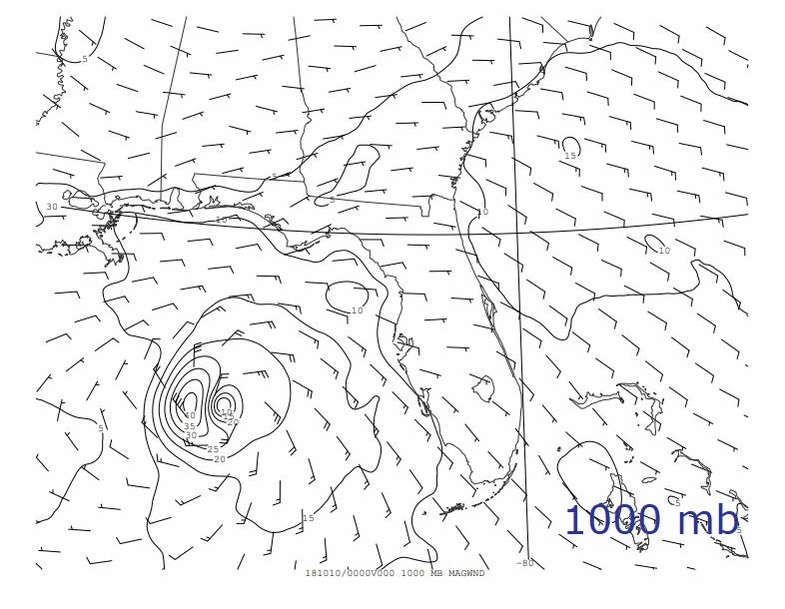
Over the ocean, Hurricane Michael was highly symmetric. Wind speeds are up to 90mph, especially around the tightly spinning eyewall. Note that Hurricane Michael seems to have two vortices in its eye, a phenomenon that will be explained further in the analysis.
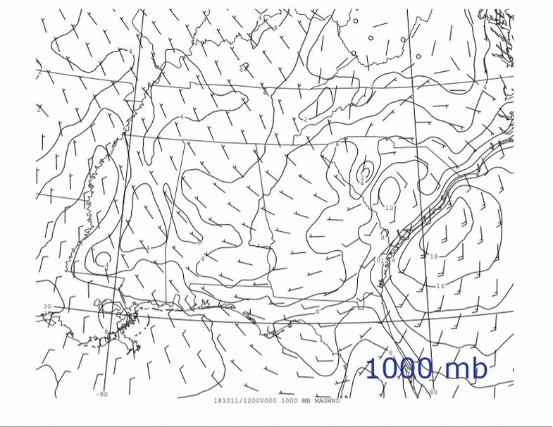
10/11 00z (making landfall)

The hurricane is still highly symmetric and has fairly fast wind speeds (though these are still reduced from over sea). Note that wind speeds are generally higher on the right of the hurricane. This is a feature of hurricanes moving because translational speed is taken into account, rather than just wind speed around the center vortex.
10/11 12z
10/11 18z

10/12 00z
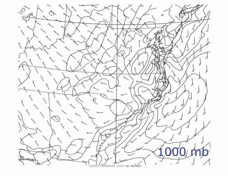
In the past three images, Hurricane Michael starts to break down. It looses a lot of its symmetry, and wind speeds drastically decrease. The cyclonic motion seems to break down at a lower elevation also, around 500mb rather than 250 as over the ocean. It is also possible to see the effect of the coastline, especially on 10/12 00z. Winds follow the coast rather than circling the vortex because of ocean-land interactions.
Wind Speed and Height
Maximum wind speed and height of the hurricane are plotted below. Height was taken as an estimate of when the strongly cyclonic motion around the eyewall disappeared, and is an general approximation.


Wind speed dramatically decreased once hitting land, and then gradually decreased as it remained over land. This is likely because the energy source of the hurricane was removed (the ocean), and less energy was available to sustain high wind speeds. Height of the hurricane also gradually decreased when the hurricane hit land. This is also likely a factor of energy loss; the energy of the ocean was used to generate strong winds in a strong vertical column, and when the energy was removed, the column had less energy to generate strong cyclonic winds at the top of the column.
Vertical Structure of Hurricanes
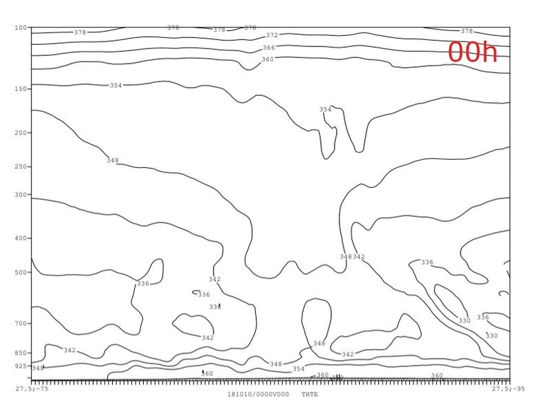
Hurricanes have several characteristics that reveal their structure. Below are vertical cross sections of Hurricane Michael of wind speeds, temperature, and relative humidity. Each cross section is taken from the above time periods, with 00h starting with 10/10 00z when the hurricane was still over water. A cross section from 24h is thus from 10/11 00z. All cross sections are west-east cross sections, so the horizontal axis is longitude.
Wind Speed

The blue lines represent the norm of wind speed contours. Dashed lines are negative wind because they are flowing south (out of the page), while solid lines are positive wind speeds flowing into the page. Black lines represent equivalent potential temperature which will be analyzed below. Important features of the wind structure are the strongly cyclonic motion around the eye of the hurricane. It is possible to see the strong vertical column where winds are spinning in a tight circle around the eye. This begins to break down after the hurricane has been over land for some time.
Also important to note is the 'unwinding' of the hurricane at high elevations. Wind speeds reverse direction at around 200 mb, as seen by the negative wind speeds in the top right of the cross sections. This is due to conservation of angular momentum as winds are spinning and rising very quickly around the eye of the hurricane, and then unwind and sink at the top of the hurricane. This feature can be clearly be seen by watching the direction of cloud rotation in the below video (start at 26sec):
Cloud tops of Hurricane Sandy showing unwinding motion. (Source: NCAR)
Temperature

Above are cross sections of potential temperature and equivalent potential temperature. Potential temperature is a temperature quantity that is conserved when a parcel of air is brought down adiabatically. Equivalent potential temperature is conserved when water vapor in the parcel is condensed, its latent heat is released, and it is brought adiabatically. Essentially, equivalent potential temperature takes into account phase change and saturation of water vapor, while potential temperature does not.
At lower elevations, there is a higher relative humidity (demonstrated below). This means that potential temperature is not conserved at lower elevations, and this is why we cannot see much effect of the hurricane on potential temperature at lower elevations. However, at high elevations, the potential temperature starts to dip right at the center of the hurricane. At lower elevations, this effect is seen instead in the plots of equivalent potential temperature, where there is a strong dip around the center of the hurricane. At higher elevations, equivalent potential does not show an effect due to low relative humidity.
Relative Humidity
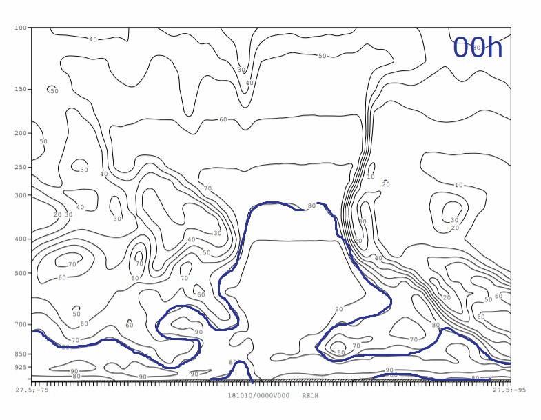
Relative humidity does not have an obvious change over land vs ocean. The plume-like structure does eventually break down over land. Not surprisingly, relative humidity is very high near the center of the hurricane, where this is a lot of rainfall and convection bringing saturated particles up into thick clouds.
Other Features of Hurricanes
Mesovortices
As mentioned earlier, Hurricane Michael seems to have two vortices in its eyewall. This is a phenomenon called 'mesovortices' and often exists in strong hurricanes. There can be multiple vortices rotating around the inside of an eye, and they generally enhance wind intensity at the eyewall. Below is a video of Typhoon Hiayan, which had three distinct mesovortices that can be seen in the image:
Mesovortices in Typhoon Haiyan (Source: University of Wisconsin-Madison CIMSS)
Heat Transfer
Hurricanes are essentially heat engines, and their high wind speeds and vertical structure are generated by warm water in oceans. The heat transport throughout the hurricane can be estimated using an approximation of hurricanes as a Carnot cycle:

Source: Tim Cronin
Hurricanes bring energy from the surface up through the center of the hurricane, where it then expands away from the vortex and eventually sinks. The potential work done by the hurricane can be calculated by Q*efficiency, where Q is the heat input rate = c_k * v (k_0 - k), where c_k is the enthalpy coefficient and k is moist enthalpy. Efficiency can be calculated by (Ts - T0)/Ts.
If we assume all potential work goes into frictional dissipation of wind at the surface, then Q*efficiency can be equated by c_d * v^3. Thus, we can solve for wind speed and find a potential intensity for the hurricane, which is the maximum wind speed that the hurricane can generate from the heat source at the surface (which is technically cut off over land).
Using values from Hurricane Michael over sea (10/10 00z) and over land (10/12 00z) efficiency, heat input, and potential work done by the hurricane can be calculated below:
| Hurricane | Efficiency | Potential Intensity |
|---|---|---|
| 10/10 00z | (300 - 200)/300 = .33 | 82 mph |
| 10/12 00z | (295 - 235)/295 = .20 | 63 mph |
For the above calculations, we are using the approximations that c_k/c_d is about 1 and (k_0 - k) is about 20,000. These are approximate values, but they demonstrate that hurricanes over land do have a smaller potential maximum wind speed. This is confirmed by the decreases in wind speed as found in the observational data.
Connection to Lab Experiment
The observational data found relates to the lab experiment in that they are both focused on generating cyclonic systems due to a heat input. The heat input in the lab experiment was the heating pad at the bottom of the tank. On Earth, the heat input is the ocean, which drives the Carnot cycle as described above. Both systems require rotation in order to generate these quickly rotating, strong vertical columns. The rotation is introduced by the rotating tank in the experiment and by the Earth's rotation in the observational data.
Studying hurricanes, both in the lab and using observational data, is very important in understanding how these extreme weather events work. Hurricanes cause intense destruction whenever they hit populations on land, and by trying to understand how they form and how they change over land, we can attempt to prepare coastal populations better for these extreme storms.